Project · Sports Technology · Team experience

Command centre for sports: 300+ athletes in a desert race

Our first command centre for sports. In a prestigious desert endurance race it followed more than 300 athletes in real time: where each one was, their speed, direction and heart rate, and where every ambulance and support team was, so the closest one could be sent to any athlete who needed help.

Athletes300+ followed live
WhereA prestigious desert endurance race
TechnologyAndroid and iOS apps, GPS, Bluetooth heart-rate belts
Our roleDesign, build and live operation
The live race

One race, seen from the command centre

Scroll through a race day on the course. A simplified, illustrative view of the platform at work.

  1. The course and the campThe route is set on the map, with its checkpoints and the camp where the mobile command centre and its mast stand.
  2. Every athlete, liveEach of the 300+ athletes is a dot on the map, sent from their own phone every few seconds: where they are, how fast, in which direction and how hard their heart is working.
  3. GPS above, a heart-rate belt on the athleteThe phone takes its position and direction from GPS satellites, and the heart rate from a belt paired over Bluetooth.
  4. A reading that looks wrongOne athlete is suddenly moving fast with a calm heart rate. The rules flag it at once: possibly in a vehicle.
  5. Help in one tapAnother athlete stops and taps for help. The call arrives with their exact position and latest readings.
  6. The closest team is directed inThe ambulance closest to them is sent, and a support truck heads to another athlete who asked for water. Both are tracked on the map until they arrive.
  7. No signal, nothing lostAcross one stretch there is no coverage. The phones keep recording and store each reading; when the signal returns, they all go up to the mast in order.
  8. After the raceEvery reading is kept. The whole race can be replayed, and each athlete's heart rate rises as a wall along the route, coloured by zone.
The challenge

A command centre where there is nothing but desert

A desert endurance race runs for days across open sand, far from roads and often far from a mobile mast. More than 300 athletes are spread over the course, with ambulances and support teams moving between them. The organisers needed to see all of it, live, from the camp.

See every athlete, live

Where each athlete is, how fast and in which direction they are moving, and how hard their heart is working, without waiting for them to reach the next checkpoint.

Send the closest help

When an athlete needs support or has an emergency, the ambulance or support team nearest to them must be found and directed to them.

Work where the signal is weak

Much of the route has weak or no mobile signal, so no reading could simply be lost when a phone went quiet.

The technology

Five layers, from the athlete to the ambulance

How the platform is put together, from the sensors an athlete carries to the teams who go out to help.

  1. 5
    On the athleteA Bluetooth heart-rate belt paired with their own phone.
    • BLE heart-rate belt
    • Phone GPS
    • Direction
    • Accelerometer
  2. 4
    In the appNative Android and iOS apps that read the sensors, keep every reading and offer the help button.
    • Android
    • iOS
    • Help button
    • Local store
  3. 3
    On the moveReadings travel over whatever network there is, and wait on the phone when there is none.
    • 4G and 3G
    • Store and forward
    • Resend on reconnect
  4. 2
    In the cloudOne platform that receives every reading, checks it against the alert rules and keeps the full record.
    • Live ingest
    • Alert rules
    • Race record
  5. 1
    In the command centre and the fieldOrganisers watch and direct help from the camp; ambulances and support teams are tracked on the same map.
    • Live map
    • Dispatch
    • Ambulance tracking
    • Support tracking
The technology slice, from the sensors on the athlete to the teams in the field.
What we did

From a heart-rate belt in the sand to a command centre in the camp

01

A heart-rate belt and a phone

Each athlete wears a Bluetooth (BLE) heart-rate belt paired with their own Android or iOS phone. Our app reads the belt and the phone's GPS together.

02

Position, direction and heart rate, streamed live

The app tracks GPS coordinates, direction of travel and heart rate in real time, and streams them all to the command centre every few seconds.

03

A mobile command centre in the desert

Set up in the race camp, it shows every athlete live on one map: location, speed, direction, path, heart rate and heart-rate zone, with alerts when a reading looks wrong.

04

Help, with the closest team sent

An athlete asks for support or reports an emergency from the app. The request arrives with their exact position, and the closest ambulance or support team is directed to them.

05

Ambulances and support teams on the same map

Medical units and support vehicles are tracked by GPS too, so the command centre always knows who is nearest and follows them to the athlete.

06

Nothing lost without signal

When coverage drops, the app keeps recording, stores every reading on the phone with its time, and sends them all as soon as the signal returns. After the race, every route and reading can be replayed.

Command centre

What the command centre sees for every athlete

Six live readings per athlete, on the map and in their own panel.

Location and path
From the phone's GPS, drawn as a trail on the race map.
Speed and direction
Worked out from the GPS trail: running, walking or at rest, and which way they are heading.
Heart rate
From the Bluetooth belt, live, beat by beat.
Heart-rate zone
The athlete's effort from easy to maximum, so an athlete in trouble stands out.
Acceleration
From the phone's accelerometer, to tell real movement from a fall or a stop.
Battery and sensor links
The phone's charge, and whether the belt and the GPS fix are both working.
The six readings shown for each athlete.
No coverage

When the signal drops, nothing is lost

Large parts of a desert route have no mobile signal. The app is built to carry on without it.

Out of coverage
  1. Readings keep recording
  2. Stored on the phone with their time
  3. Help requests queued first
Signal back
  1. Help requests sent first
  2. Stored readings resent in order
  3. Route and readings complete
Store and forward: the phone buffers every reading and resends it when the signal returns.
Results

What it achieved

300+

athletes followed live on one map, in the desert

1 tap

to ask for support or report an emergency, with the athlete's exact position

Closest

ambulance or support team found and directed to the athlete

Analytics

What the data shows, during and after the race

The same readings that keep athletes safe on the day become analysis afterwards: how hard each athlete worked, what looked wrong, and how the field spread out.

Time in each heart-rate zoneOne athlete's whole race, from the chest strap.Share of race timeZone 50.24%Zone 45.01%Zone 326.05%Zone 267.45%Zone 11.25%
Speed against heart rateEvery dot is a reading. The rules watch for the corners where the two do not agree.Speed (km/h)Heart rate (bpm)Possibly in a vehicleStrained at restNormalVehicle alertHeart-rate alert
How the field spread outDistance covered by each athlete over the race. The red line stops: that athlete asked for help.HoursDistance (km)CheckpointCheckpointCheckpointLeaderThe fieldAsked for help
Heart-rate zones from one athlete's race; the other two charts are illustrative.
Connected projects

Part of a larger programme

A closer look

Inside the work
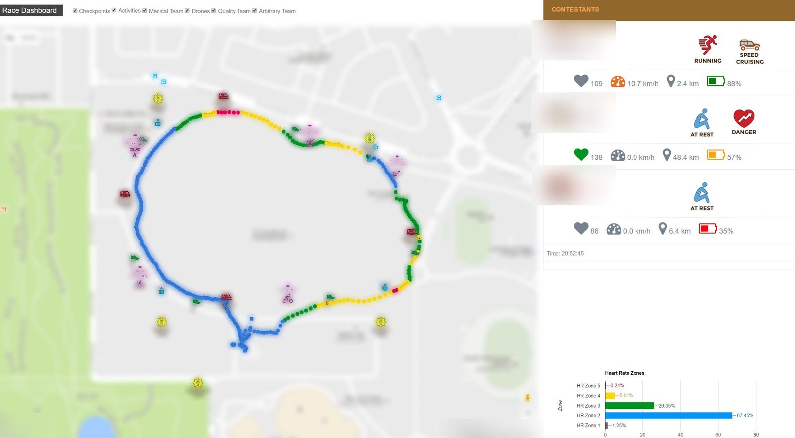
The live race dashboard: a route on the map with medical and support teams, and each athlete's heart rate, speed, distance and battery; names and places blurred
The live dashboard: route, teams on the map, and every athlete's readings.
After the race: the whole race in 3D, readings rising along the route.
Replaying the field: one colour per athlete.
Capabilities

What it drew on

Android and iOS appsGPS trackingBluetooth sensorsReal-time dashboardsAlert rulesOffline-first data syncEmergency dispatchFleet trackingPost-event analytics

Turn ambition into results.

Tell us where you want to be. We will show you the fastest way to get there, with the right mix of strategy, technology and AI.